Navigation for the Weekend Boater
When you’re just starting, navigation can seem like one of the most daunting things to learn. Where are you going, how are you going to get there, and then how are you going to get home? Everything looks so different from the water! But there are three basic ways that it is done, and believe it or not, none of them are overly complicated.
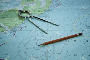
To start, you need to have a nautical chart and learn how to read it. The second skill you need to master is always to be asking yourself, “What if?” What if the visibility gets reduced and we can’t see far enough to find our way home? What if our engine dies and we need to call for help, how will we tell them where we are? What if we drift on the current and become disoriented, how will we figure out our way back? Hopefully, none of that happens to you, but if you have a plan, chances are you’ll be ready for any adventures or misadventures.
Three Ways to Navigate
 There are three basic ways to navigate: visually, using dead reckoning, or by using electronic aids. Boaters need to be able to do all three in case one of the other methods fails. For example, you can visually navigate just fine, unless a thick fog rolls in. You can use GPS every day for years, but what happens when one day your GPS unit fails, and you are out of the sight of land? Boaters can’t often just pull over and ask for directions, so knowing how to get where you are going is an important thing to think about.
It should be noted that it is never as easy as hopping in the boat and taking off. To be prepared to boat in a new area, you should start looking at the charts well before you cast off your dock lines. Have a rough idea of your plan and of places to stop along the way. Get a mental picture of any shallows or hazards along your route. Don’t try to figure it out on the water when you might need to be doing other things.
Visual Navigation
Using your eyeballs is always the simplest and easiest way to navigate. You do it all the time when you drive your car. You navigate along the road, and you turn left at the McDonalds and then right at the hardware store. If you’re driving your boat on a lake or nearshore waters, this is usually how it’s done.
Of course, there’s no McDonalds to mark your turn. ATONs, or aids to navigation, are your signposts along the way. These are daymarks or buoys placed in the water that help you identify where you are. Daymarks are signs on piling or other structures that may or may not be lighted. Buoys are usually found in areas where the channel shifts around. The Coast Guard or private parties maintain ATONs, depending on where they are found.
Knowing where the ATONs are means you will have to have a nautical chart. Paper charts are available at most tackle shops and West Marine. US Government charts are available for free on the internet. Keeping an updated chart on board is an important safety feature on every boat.
It’s also important to note that ATONs are not that easy to decipher without both having some practice and having a chart in front of you. “Red right returning” is the common mantra taught to new boaters, meaning keep the red triangles on your right (starboard) side when returning to port. But some channels change midway, and it’s not necessarily when you are returning but when the channel returns from the sea. It gets confusing, and even the most experienced skippers need to study the chart to figure it out sometimes.
One failure of visual navigation is the fact that you cannot navigate away from features that you cannot see. Shoal areas that are too shallow for your boat may not be obvious or marked, so you will have to use other reference points or some other form of navigation to ensure you don’t wind up aground.
Dead Reckoning
Navigating by line-of-sight and eyeball is fine when you can see where you are going. If you’re cruising long distances, leaving the sight of land, or navigating in reduced visibility, you will need another method.
Every boater must have at least some basic understanding of dead reckoning. Teaching dead reckoning is beyond the scope of this article, but it involves plotting your course on a chart between two positions. You then calculate a compass heading and the time it should take you to run between those two points. If you do it correctly, you will arrive at your destination with no other reference than your compass and your watch. You can navigate great distances this way, and it is the fundamental skill necessary for crossing a large bay, an ocean, or even piloting an airplane.
If you haven’t practiced dead reckoning, safe boating courses cover this skill along with how to read ATONs correctly. Safe boating classes are available all over the country and are relatively inexpensive. Most classes are offered by the US Power Squadron or Coast Guard Auxiliary.
Electronic Navigation
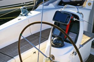 GPS has revolutionized pretty much every industry, from driving a car, skippering a vessel, or piloting an aircraft. GPS uses satellites to pinpoint your position. Most marine GPS units are more appropriately called chartplotters, meaning they not only show your position but display it atop an electronic chart. The chart shows depths, ATONs, landmasses, and everything else you might need to know.
You can use your GPS in many ways. The most straightforward technique is to use it to backup your visual navigation. Use the chartplotter to help you spot ATONs or inlets that are hard to spot with your eyes. You can get close enough to it that you should be able to see it visually.
You can also use your GPS to backup your dead reckoning. You can check the accuracy of your calculations along the way since the GPS is always showing your position.
GPS can be used to calculate your course and heading between two objects. The GPS can navigate you to a point using the “direct to” function, or can even navigate an entire route between your departure and your destination. The fanciest units have auto-routing functions that calculate a route based on your draft, water depths, and channels available.
With so much computing power available at the touch of a button, it’s easy to get pretty complacent. GPS is subject to errors and can be easily misinterpreted, especially if you are new to using it. It is easier than you think to program the unit incorrectly and wind up somewhere you don’t want to be. Always back up GPS navigation with visual piloting and double-check compass courses.
Equipment to Consider
Charts and Compass
 These are the two most important tools you should have on your boat. The best thing about a chart and compass is that their batteries never fail. Learn where to mount your compass in my article.
Remember to keep your chart updated. ATONs change, and channels shift. If you’re going somewhere new, make sure you’re looking at the most recent charts. To do dead reckoning, you will also need a pair of dividers and a set of parallel rulers.
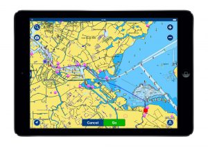
GPS Chartplotters
GPS units come in a wide range of sizes, from pocket units to 16-inch widescreens that mount on your panel. Most small boats have a five to seven-inch model, which offers more than enough functionality for what most people need.
Even the smallest GPS’s today have a chartplotter function. The charts may cost additional money after the purchase of the GPS, so be sure to find out if the charts are included. You’ll also want to keep your charts updated regularly.
Apps for Navigation
Of course, pretty much every everybody carries a GPS in their pocket nowadays. Smartphones include a GPS chip, and many of the top marine GPS manufacturers make apps for your smartphone too. Some of the nicer apps connect to your boat’s chartplotter using WiFi or Bluetooth, enabling you to share charts, waypoints, and routes between the two devices. Check out our review of marine apps.
The apps are easy to use and less expensive to keep updated. Often apps require an annual subscription that is based on where you boat and what charts you need to download. One of the best features of the apps is the ability to have access to your charts at any time and any place. They also can serve as a backup unit should your onboard chartplotter fail.
There are more apps than we could list here, but ones that we’ve had good luck with include Navionics Boating and AquaMaps. Boating uses Navionics charts, which are some of the best electronic charts in the industry. Their crowd-sourced SonarCharts offer updated underwater contours in some areas. The AquaMaps App uses government charts and allows for many overlays including the Army Corps of Engineers surveys and cruising guide data.
It’s worth mentioning here that many folks like to use their tablets as a chartplotter. This works great and can be an inexpensive way to get a big-screen chartplotter at your helm. However, be aware that WiFi-only tablets do not usually come with a GPS chip, so you might need an external unit. Cellular-enabled tablet models, however, typically do have an internal GPS chip.
Are Apps Better than the Old-Fashioned Way?
 There is no doubt that apps and GPS have made navigating easier. While we still need a few minutes of chart study before we set out, GPS enables us to quickly calculate courses and times en route without tedious manual measuring and calculations.
This certainly doesn’t mean that dead reckoning is dead. It’s essential for a boater to be able to calculate their position no matter where they are. GPS does sometimes fail, both from power issues and satellite reception issues. As with anything else on board, you need to ask the tough “what if” questions. What if you can’t see land and the GPS unit dies?
Conclusion
Even if you only boat on the smallest lake, you need some navigation skills. No, every mariner does not need to know celestial navigation and every technicality of position fixing. But every boater does need to be able to navigate and calculate their exact position using more than one method just in case their favorite fails one day.
Remember, don’t get too complacent using your GPS. Dust off the old chart and compass every once in a while and calculate a position fix for the fun of it. It just might save your life one day, or at least keep you off the sandbar.
![Read more about the article Best Manual Trim Tabs for Boats [Buyers Guide]](https://towers4boats.com/wp-content/uploads/2020/10/Best-Manual-Trim-Tabs-for-Boats-300x176.jpg)